
Concorde Doddaballapur Location
Upcoming - Concorde has not announced this project; no K-RERA registration is shown as at 4 October 2026.
Concorde Doddaballapur Around Doddaballapura
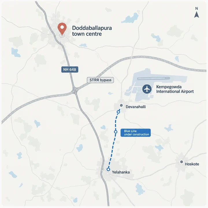
Doddaballapura is a town and taluk in Bangalore Rural district, set on NH 648, with the KIADB textile and apparel park about 5.2 km from its centre and Nandi Hills about 25.9 km away by road. It is the town where Concorde Group is understood to be planning a plotted development, though Concorde has announced no parcel. Inside the Bengaluru search area, Concorde Sienna helps buyers keep the map conversation grounded in actual routines instead of only distance claims.
Every number on this page is measured from one fixed point: the town centre. All distances are road distances from Doddaballapura town centre (the bus stand), because Concorde has not announced a parcel. They are routed kilometres, rounded, and they describe the town, not a plot. Once Concorde names a parcel, the figures that matter will be the ones measured from its gate.
Three things define this address for a plot buyer. The town has its own railway station and its own employment base, so it is not a dormitory village. The Satellite Town Ring Road skirts it and links it to the airport belt and to Hoskote. And it is far enough out that no metro or suburban line serves it today. The sections below take each in turn.
Doddaballapura at a Glance
Detail / Doddaballapura
Roads and the Satellite Town Ring Road
The Satellite Town Ring Road is the biggest change to how this town connects. Its Dobbaspet to Doddaballapura to Hoskote stretch, about 80 km and signed NH 648, was inaugurated on 11 March 2024. It is tolled in two sections: the Doddaballapura to Hoskote section from 17 November 2023 and the Dobbaspet to Doddaballapura section from 14 June 2024. It has now carried traffic for more than two years, so buyers can judge it on how it drives rather than on a promise.
The ring road skirts the town as a bypass, and vehicles join and leave it at specific junctions. A plot's convenience therefore depends on which junction serves its approach road, not on a straight-line gap to the road. Ask which entry a layout uses and how its internal roads meet the public road.
East of the town, the ring road meets the Bengaluru-Chennai Expressway near Hoskote. The Karnataka section of the expressway from Hoskote opened on 9 December 2024. Its western start is about 46.0 km by road from the town centre, so the expressway serves eastbound trips towards Kolar and beyond more than it serves the town directly.
| Place | Road km | What it is |
|---|---|---|
| Devanahalli | about 22.3 | Airport-belt town |
| Yelahanka | about 24.8 | North Bengaluru suburb and first big retail and hospital cluster |
| Muddenahalli | about 26.2 | Village on the Chikkaballapura side |
| Nandi Hills (summit) | about 25.9 | Hill station and weekend destination |
| Hesaraghatta | about 28.8 | Lake and grassland belt on Bengaluru's northwest edge |
| Chikkaballapura | about 29.6 | District headquarters town |
| Nelamangala | about 32.7 | Tumakuru Road side |
| Hebbal flyover | about 34.7 | Gateway to central Bengaluru |
| Dobbaspet | about 34.8 | Western start of the ring road stretch |
| Majestic (Kempegowda Bus Station) | about 41.7 | Central Bengaluru |
| Bengaluru-Chennai Expressway western start, near Hoskote | about 46.0 | Expressway entry |
| Hoskote | about 51.5 | East Bengaluru and the ring road's far end |
All distances are road distances from Doddaballapura town centre (the bus stand), because Concorde has not announced a parcel.
Airport, Metro and Rail
Kempegowda International Airport is about 32.3 km by road from the town centre, and Devanahalli, the airport-belt town, is about 22.3 km. The airport is also where Namma Metro's Blue Line is meant to end. That line is under construction and no opening date is confirmed, so it should not be part of any buying calculation today. It does not reach Doddaballapura: its nearest stations are about 25 km away by road.
What the town does have is a railway station on the existing line, about 2.2 km from the bus stand. No metro or suburban rail line serves Doddaballapura town.
| Place | Road km | Status |
|---|---|---|
| Doddaballapura railway station | about 2.2 | Existing station in the town |
| Yelahanka Junction railway station | about 25.6 | Existing station |
| Kempegowda International Airport (bus station) | about 32.3 | Operating airport |
| Yelahanka metro station (Blue Line) | about 25.5 | Under construction; opening date not confirmed |
| Bagalur Cross metro station (Blue Line) | about 26.0 | Under construction; opening date not confirmed |
| Airport City metro station (Blue Line) | about 30.0 | Under construction; opening date not confirmed |
| KIAL Terminals metro station (Blue Line) | about 33.1 | Under construction; opening date not confirmed |
Road km from the town centre (the bus stand).
Work Hubs
Doddaballapura has an employment base of its own, and that is a large part of why people live here. The KIADB Doddaballapura textile and apparel park and the Obedanahalli industrial area sit within a few kilometres of the town centre. Further out, the Devanahalli side of the airport belt carries the Foxconn plant, and Manyata Tech Park is the large Bengaluru tech campus on the list.
| Place | Road km |
|---|---|
| Doddaballapura textile park area (KIADB) | about 5.2 |
| Ajax Engineering, Obedanahalli | about 5.9 |
| Obedanahalli Industrial Area (KIADB) | about 6.1 |
| Hitachi Astemo | about 6.2 |
| Foxconn plant (Devanahalli side) | about 12.0 |
| Manyata Tech Park | about 32.8 |
Road km from the town centre (the bus stand).
Schools and Colleges
The town and its surroundings carry a school and college list that runs from a Jawahar Navodaya Vidyalaya to private universities along the northern corridor. Families weighing a plot here as a long-term home can look at education without a trip to Yelahanka.
| Institution | Road km |
|---|---|
| RL Jalappa Institute of Technology | about 2.8 |
| Jawahar Navodaya Vidyalaya | about 3.5 |
| GITAM University | about 8.2 |
| Amity University | about 11.6 |
| Harrow International School | about 12.1 |
| Cambridge Institute of Technology North Campus | about 13.5 |
| Vidyashilp University | about 17.5 |
| Presidency University | about 18.3 |
Road km from the town centre (the bus stand).
Hospitals and Malls
Healthcare in the town is a government hospital and several private hospitals, with Manipal Hospital and the ESI Hospital among the nearest named options. Larger multispeciality hospitals also cluster in Yelahanka and on Bellary Road. Retail follows the same pattern: the malls listed below are at Yelahanka, Devanahalli and further into the city.
| Hospital | Road km |
|---|---|
| Manipal Hospital, Doddaballapura | about 4.8 |
| ESI Hospital | about 5.4 |
| Sparsh Hospital, Yelahanka | about 26.3 |
| Manipal Hospital, Bellary Road | about 29.1 |
| Mall | Road km |
|---|---|
| Sattva Park Cubix | about 23.9 |
| Centro Mall | about 24.1 |
| The Galleria Mall | about 24.4 |
| Phoenix Mall of Asia | about 28.6 |
| Bhartiya Mall | about 32.2 |
Road km from the town centre (the bus stand).
Honest Trade-offs
Doddaballapura suits buyers who plan to hold land or build in time, and the table lists what it asks in return.
| Trade-off | What it means for a buyer |
|---|---|
| Distance | About 32 km from the airport and about 42 km from Majestic by road, with no metro or suburban line to the town. |
| Ring road access | The ring road skirts the town, but entry is at junctions, not at a plot's gate. Ask which junction a layout uses. |
| Industrial neighbours | Textile, engineering and manufacturing units are part of the belt. Check what surrounds a specific parcel. |
| Crowded launches | At least seven of the twelve newest K-RERA registrations in the taluk are plotted layouts, and price points across them differ by nearly two times. |
| Khata | Panchayat or municipal khata, rather than BDA A khata, is common in the belt. Ask which applies and what the route to the next khata is. |
| Forecasts | Dates for the Blue Line and other infrastructure are forecasts, not commitments. |
| Planning authority | The Doddaballapura Planning Authority (constituted 20 March 2018) sanctions layouts in the town's planning area, and BIAAPA covers the Devanahalli side. Which one applies depends on the parcel. |
What to Ask For When Concorde Announces
When Concorde publishes a parcel, ask for its survey numbers and the distance from its gate to the nearest ring road junction, the planning authority that sanctioned the layout, and the K-RERA registration number. Confirm the K-RERA registration on the official K-RERA site before you pay anything: https://rera.karnataka.gov.in/viewAllProjects?language=en
For the project overview, see Concorde Doddaballapur Overview. For the layouts Concorde has built elsewhere, see Concorde Doddaballapur Masterplan and Concorde Doddaballapur Amenities. To hear when Concorde announces the project, use the contact page.
Concorde Doddaballapur Location FAQs
Where is Concorde Doddaballapur located?
Concorde Group is understood to be planning the development at Doddaballapura, the town and taluk in Bangalore Rural district on NH 648. Concorde has not announced a parcel, so every distance on this site is measured by road from Doddaballapura town centre (the bus stand): about 32.3 km to Kempegowda International Airport, 22.3 km to Devanahalli, 24.8 km to Yelahanka and 41.7 km to Majestic.
How far is Doddaballapura from Bengaluru and the airport?
From Doddaballapura town centre it is about 32.3 km by road to Kempegowda International Airport and about 41.7 km to Majestic, with Hebbal flyover about 34.7 km away. These are distances from the town centre, not from any project, and the town has no metro or suburban rail line. Yelahanka is about 24.8 km away by road.
Is there a metro or railway station near Doddaballapura?
Doddaballapura has a railway station about 2.2 km from the town centre. The Namma Metro Blue Line to the airport is under construction with no confirmed opening date, and its nearest stations, Yelahanka and Bagalur Cross, are about 25.5 km and 26.0 km away by road. No metro line reaches the town, so most daily trips rely on the road.
What is the status of the Satellite Town Ring Road at Doddaballapura?
The stretch of the Satellite Town Ring Road from Dobbaspet through Doddaballapura towards Hoskote was inaugurated on 11 March 2024 and is tolled in two sections, from 17 November 2023 and from 14 June 2024. The ring road skirts the town as a bypass with entries at specific junctions, so ask which one serves any plot you consider. It has now been in operation for more than two years.
Does the Bengaluru-Chennai Expressway reach Doddaballapura?
The Karnataka section of the Bengaluru-Chennai Expressway opened from Hoskote on 9 December 2024. Its western start near Hoskote is about 46.0 km by road from Doddaballapura town centre, reached along the ring road, so the town has no direct entry. Hoskote itself is about 51.5 km away by road.
What jobs, schools and hospitals are near Doddaballapura?
The KIADB textile park area is about 5.2 km from the town centre and the Obedanahalli Industrial Area about 6.1 km, with Ajax Engineering about 5.9 km and Hitachi Astemo about 6.2 km away. Jawahar Navodaya Vidyalaya is about 3.5 km away and GITAM University about 8.2 km, and Manipal Hospital, Doddaballapura is about 4.8 km away. The town has a government hospital and several private hospitals, while larger multispeciality hospitals also cluster in Yelahanka and on Bellary Road.
Be Early to the Announcement
The first announcement is the one worth being early for. Register your interest and you will hear when Concorde announces the project.
Register interest